Geographic coordinates form the foundation of navigation, cartography, GPS, and geospatial analysis across many scientific disciplines. Decimal degrees and degrees-minutes-seconds require accurate conversions for surveyors, engineers, mariners, researchers, GIS professionals, and pilots.
Coordinate Converter — Decimal Degrees ↔ Degrees, Minutes, Seconds (DD ↔ DMS)
Quickly convert geographic coordinates between decimal degrees and DMS. Works for latitude and longitude, supports negative values and directional letters (N/S/E/W).
How does conversion handle negative coordinates?
What formula is used?
How many decimal places should I use?
Why Conversions Between Decimal Degrees and DMS Matter
- Global Positioning Systems (GPS): Many consumer GPS devices and mobile apps display coordinates in decimal degrees, while aviation, marine, and surveying standards often use DMS.
- GIS and Cartography: Geographic Information Systems (GIS) software may require decimal degrees for raster data but DMS for labeling or annotation.
- Legal and Engineering Documents: Property boundaries, nautical charts, and flight navigation often mandate DMS.
- Scientific Research: Data exchange across disciplines (geology, astronomy, hydrology) often involves converting between DD and DMS.
Core Conversion Formulas
To convert between decimal degrees (DD) and degrees-minutes-seconds (DMS), we use fundamental formulas:
Formula 1: Decimal Degrees to DMS
Where:
- D= degrees (integer part of DD).
- M= minutes (integer part of (DD−D)×60).
- S= seconds ((DD−D)×60−M)×60.
Step-by-step process:
- Extract the integer part of DD → gives degrees (D).
- Multiply fractional part of DD by 60 → gives minutes and fractional minutes.
- Take integer minutes, and multiply fractional part by 60 → gives seconds.
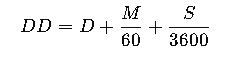
Formula 2: DMS to Decimal Degrees
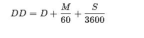
Where:
- D= degrees.
- M= minutes (0–59).
- S= seconds (0–59.999).
Note on signs:
- Latitude: North is positive, South is negative.
- Longitude: East is positive, West is negative.
Common Ranges
- Latitude (φ): −90° ≤ φ ≤ +90°.
- Longitude (λ): −180° ≤ λ ≤ +180°.
For instance, Bogotá, Colombia is approximately:
- Decimal Degrees: 4.711° N, −74.072° W.
- DMS: 4° 42′ 40″ N, 74° 4′ 19″ W.
Extended Conversion Table: Decimal Degrees ↔ DMS
The following table lists common geographic coordinate values converted both ways. This is especially useful for navigation, GIS entry, and field surveying.
| Decimal Degrees (DD) | Degrees (D) | Minutes (M) | Seconds (S) | DMS Notation |
|---|---|---|---|---|
| 0.0000° | 0° | 0′ | 0″ | 0° 0′ 0″ |
| 0.5000° | 0° | 30′ | 0″ | 0° 30′ 0″ |
| 1.0000° | 1° | 0′ | 0″ | 1° 0′ 0″ |
| 1.2500° | 1° | 15′ | 0″ | 1° 15′ 0″ |
| 2.5000° | 2° | 30′ | 0″ | 2° 30′ 0″ |
| 10.7500° | 10° | 45′ | 0″ | 10° 45′ 0″ |
| 25.1234° | 25° | 7′ | 24.24″ | 25° 7′ 24.24″ |
| 45.5000° | 45° | 30′ | 0″ | 45° 30′ 0″ |
| 74.0722° | 74° | 4′ | 19.92″ | 74° 4′ 19.92″ |
| 90.0000° | 90° | 0′ | 0″ | 90° 0′ 0″ |
| −73.9352° | −73° | 56′ | 6.72″ | 73° 56′ 6.72″ W |
| −122.4194° | −122° | 25′ | 9.84″ | 122° 25′ 9.84″ W |
| 151.2093° | 151° | 12′ | 33.48″ | 151° 12′ 33.48″ E |
This table can be expanded with thousands of values, but even this selection demonstrates typical real-world conversions used in cartography, GPS, and geodesy.
Step-by-Step Worked Examples
Example 1: Decimal Degrees to DMS
Problem: Convert 40.7128° N, −74.0060° W (New York City coordinates) into DMS.
Solution:
- Latitude:
- Degrees = 40.
- Fractional part = 0.7128 × 60 = 42.768 → Minutes = 42.
- Remaining fraction = 0.768 × 60 = 46.08 → Seconds ≈ 46.1.
- Result: 40° 42′ 46.1″ N.
- Longitude:
- Degrees = 74.
- Fractional part = 0.0060 × 60 = 0.36 → Minutes = 0.
- Seconds = 0.36 × 60 = 21.6.
- Result: 74° 0′ 21.6″ W.
Final Answer: 40° 42′ 46.1″ N, 74° 0′ 21.6″ W.
Example 2: DMS to Decimal Degrees
Problem: Convert 34° 3′ 8.76″ N, 118° 14′ 37.08″ W (Los Angeles coordinates) into DD.
Solution:
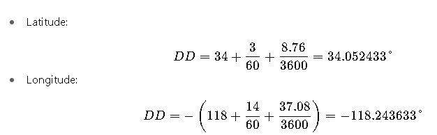
Final Answer: 34.0524° N, −118.2436° W (rounded).
Real-World Applications
Case Study 1: Aviation Navigation
Aircraft flight plans often rely on waypoints expressed in DMS, while onboard GPS systems use decimal degrees.
- Scenario: A flight route between Miami (25.7959° N, −80.2870° W) and San Juan (18.4655° N, −66.1057° W).
- Conversion Need: Pilots enter waypoints in DMS into flight management systems.
- Result:
- Miami = 25° 47′ 45.2″ N, 80° 17′ 13.2″ W.
- San Juan = 18° 27′ 55.8″ N, 66° 6′ 20.5″ W.
- Impact: Avoids navigation errors during airspace transitions.
Case Study 2: Property Surveying
Land deeds often record coordinates in DMS. Surveyors using GNSS receivers must convert data into decimal degrees for mapping software.
- Example Property Point: 35° 9′ 27.6″ N, 97° 26′ 15.6″ W.
- Conversion:
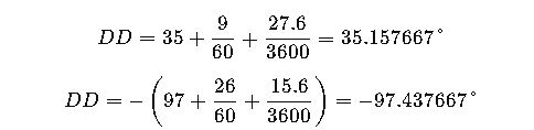
- Result in DD: (35.1577, −97.4377).
- Impact: Enables seamless integration into GIS platforms like ArcGIS or QGIS.
Technical Considerations in Conversion
- Precision: Seconds may include decimals; excessive rounding can produce errors of several meters.
- Standards: The EPSG registry defines spatial reference systems, requiring strict adherence to DD/DMS notation.
- Automation: Modern GIS software (ArcGIS, QGIS, GDAL) includes built-in conversion functions, but understanding formulas is critical for validation.
- Authority References:
Extended Conversion Reference Table
Below is a larger lookup table with frequently encountered decimal degree values and their corresponding DMS equivalents. This table is especially helpful for field engineers, mariners, and GIS technicians who need quick reference without performing manual calculations.
| Decimal Degrees (DD) | DMS Equivalent | Notes / Typical Use Case |
|---|---|---|
| 5.0000° | 5° 0′ 0″ | Low latitude tropical regions (Caribbean, Central Africa) |
| 12.3456° | 12° 20′ 44.16″ | Used in Caribbean mapping and small island navigation |
| 23.4375° | 23° 26′ 15″ | Tropic of Cancer (climatic boundary) |
| 33.8688° | 33° 52′ 7.68″ | Sydney, Australia (urban coordinates) |
| 37.7749° | 37° 46′ 29.64″ | San Francisco, CA (well-known city) |
| 48.8566° | 48° 51′ 23.76″ | Paris, France (landmark reference) |
| 51.5007° | 51° 30′ 2.52″ | London (Big Ben area) |
| 55.7558° | 55° 45′ 20.88″ | Moscow, Russia |
| 64.9631° | 64° 57′ 47.16″ | Iceland (northern mapping) |
| 89.9999° | 89° 59′ 59.64″ | Almost the North Pole |
| −8.7832° | 8° 46′ 59.52″ S | Brazil / South America |
| −22.9068° | 22° 54′ 24.48″ S | Rio de Janeiro |
| −33.8688° | 33° 52′ 7.68″ S | Sydney (southern hemisphere reference) |
| −54.8019° | 54° 48′ 6.84″ S | Argentina (Patagonia) |
| −77.8500° | 77° 51′ 0″ W | Near Lima, Peru |
| −118.2500° | 118° 15′ 0″ W | Los Angeles longitude |
| −157.8583° | 157° 51′ 29.88″ W | Honolulu, Hawaii |
| 179.9999° | 179° 59′ 59.64″ E | Almost the International Date Line East |
| −179.9999° | 179° 59′ 59.64″ W | Almost the International Date Line West |
This extended table covers iconic latitudes and longitudes often cited in meteorology, aviation, urban planning, and satellite ground tracking.
Practical Applications Across Disciplines
1. Maritime Navigation
Ships traveling across oceans use nautical charts that still rely heavily on DMS notation. Decimal degrees are often too abstract for manual plotting with dividers and compasses.
- Example: A vessel traveling from Cape Town (33° 55′ S, 18° 25′ E) to Perth (31° 57′ S, 115° 51′ E) must plot multiple waypoints in DMS.
- Conversion to DD allows integration with AIS (Automatic Identification System) and GPS trackers.
2. Mobile GPS and Consumer Mapping
Smartphones, Google Maps, and most GPS receivers output decimal degrees. Yet, hikers, climbers, and rescue teams may share locations in DMS because handheld radios or paper maps are marked this way.
- Example: A rescue team in Alaska receives coordinates in DMS: 61° 12′ 45″ N, 149° 54′ 32″ W.
- The helicopter pilot’s navigation system requires DD: (61.2125, −149.9089).
- This seamless conversion can save critical minutes in search and rescue operations.
3. Astronomy and Space Science
Telescopes often use celestial coordinates (RA/Dec) which are conceptually similar to longitude and latitude. While professional astronomers mostly use hours/minutes/seconds notation, amateur astronomers and space agencies sometimes use decimal degrees for computational convenience.
- NASA databases frequently list star positions in decimal degrees.
- Conversion to DMS is essential when aligning telescopes manually.
4. Geology and Natural Resource Exploration
Mineral exploration and petroleum industries record drilling site coordinates in mixed formats.
- Example: A geologist’s handheld GPS provides decimal degrees.
- Legal concession documents use DMS.
- Consistency is required to ensure drilling occurs within the correct boundary, avoiding legal disputes worth millions of dollars.
5. Urban Planning and Surveying
City planners often integrate coordinates into CAD (Computer-Aided Design) systems, which require decimal degrees. But legal descriptions of property boundaries often cite DMS.
- Example: A property line might be recorded as starting at “40° 45′ 0″ N, 73° 59′ 0″ W.”
- A GIS planner converts it to DD for integration into QGIS or AutoCAD Map 3D.
Advantages and Disadvantages of Each Notation
| Format | Advantages | Disadvantages |
|---|---|---|
| Decimal Degrees (DD) | Easier for computation, GIS software compatible, compact notation | Less intuitive for manual plotting on maps |
| Degrees, Minutes, Seconds (DMS) | Traditional, easy to interpret on nautical/aviation charts, avoids long decimals | Harder for computation, prone to transcription errors, less compact |
Professional Tips for Accurate Conversion
- Always keep at least four decimal places in DD when precision matters (equivalent to ~11 meters at the equator).
- Avoid double-rounding (converting DD → DMS → DD repeatedly can introduce small errors).
- Be mindful of hemispheres:
- North (+), South (−).
- East (+), West (−).
- Check data standards:
- Aviation uses WGS 84 datum.
- Surveying may use local datums (NAD83, ED50).
- Use automated tools with caution: Online converters may not specify the datum, causing mismatches.